
From NASA:
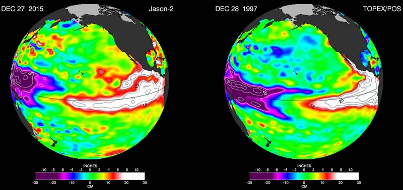
The latest Jason-2 image bears a striking resemblance to one from December 1997, by Jason-2’s predecessor, the NASA/Centre National d’Etudes Spatiales (CNES) Topex/Poseidon mission, during the last large El Niño event. Both reflect the classic pattern of a fully developed El Niño. The images can be viewed at:
>snip<
While scientists still do not know precisely how the current El Niño will affect the United States, the last large El Niño in 1997-98 was a wild ride for most of the nation. The “Great Ice Storm” of January 1998 crippled northern New England and southeastern Canada, but overall, the northern tier of the United States experienced long periods of mild weather and meager snowfall. Meanwhile, across the southern United States, a steady convoy of storms slammed most of California, moved east into the Southwest, drenched Texas and — pumped up by the warm waters of the Gulf of Mexico — wreaked havoc along the Gulf Coast, particularly in Florida.
>snip<
The new Jason-2 image shows that the amount of extra-warm surface water from the current El Niño (depicted in red and white shades) has continuously increased, especially in the eastern Pacific within 10 degrees latitude north and south of the equator. In the western Pacific, the area of low sea level (blue and purple) has decreased somewhat from late October. The white and red areas indicate unusual patterns of heat storage. In the white areas, the sea surface is between 6 and 10 inches (15 to 25 centimeters) above normal, while in the red areas, it is about 4 inches (10 centimeters) above normal. The green areas indicate normal conditions. The height of the ocean water relates, in part, to its temperature, and is an indicator of the amount of heat stored in the ocean below.
Within this area, surface temperatures are greater than 86 degrees Fahrenheit (30 degrees Celsius) in the central equatorial Pacific and near 70 degrees Fahrenheit (21 degrees Celsius) off the coast of the Americas. This El Niño signal encompasses a surface area of 6 million square miles (16 million square kilometers) — more than twice as big as the continental United States.
While no one can predict the exact timing or intensity of U.S. El Niño impacts, for drought-stricken California and the U.S. West, it’s expected to bring some relief.
“The water story for much of the American West over most of the past decade has been dominated by punishing drought,” said JPL climatologist Bill Patzert. “Reservoir levels have fallen to record or near-record lows, while groundwater tables have dropped dangerously in many areas. Now we’re preparing to see the flip side of nature’s water cycle — the arrival of steady, heavy rains and snowfall.”
In 1982-83 and 1997-98, large El Niños delivered about twice the average amount of rainfall to Southern California, along with mudslides, floods, high winds, lightning strikes and high surf. But Patzert cautioned that El Niño events are not drought busters. “Over the long haul, big El Niños are infrequent and supply only seven percent of California’s water,” he said.
“Looking ahead to summer, we might not be celebrating the demise of this El Niño,” cautioned Patzert. “It could be followed by a La Niña, which could bring roughly opposite effects to the world’s weather.”
And, as Wikipedia notes:
The 1997–98 El Niño was regarded as one of the most powerful El Niño-Southern Oscillation events in recorded history, resulting in widespread drought, flooding and other natural disasters across the globe. It caused an estimated 16% of the world’s reef systems to die, and temporarily warmed air temperature by 1.5 °C, compared to the usual increase of 0.25 °C associated with El Niño events.[1]
It led to a severe outbreak of Rift Valley fever after extreme rainfall in north-eastern Kenya and southern Somalia.[2] It also led to record rainfalls in California during the water season of 1997–98 and one of Indonesia’s worst droughts on record. 1998 ultimately became the hottest year in recorded history (up until then).
